
Page 42 - TNB_Ebook_ESG_2024
P. 42
https://www.tnb.com.my/sustainability/esg-stories/
Biodiversity & Land Use
Clearing vegetation can lead to: The key benefits of THySIS include: The key benefits of THySIS include:
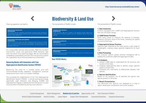
1. Data Collection:
Reduced Carbon Sequestration Compliance with regulations A drone equipped with LiDAR and Hyperspectral sensors
Forests play a vital role in absorbing carbon dioxide, a greenhouse gas contributing to THySIS empowers TNB Grid to adhere to the Malaysian Forestry Department's flies over the forest canopy.
climate change. Studies estimate a potential loss of up to 70 tons of CO2 per kilometre requirements by effectively avoiding areas with endangered species during route
per year for high-voltage lines. planning. 2. LiDAR Sensor Function:
Emits laser pulses to measure the distance to treetops,
Increased Risk of Soil Erosion and Landslides creating a 3D point cloud of the forest, revealing the spatial
Preservation of biodiversity structure of the trees.
Forests in hilly terrain, where over 80% of Malaysia's forest reserves are located,
offer crucial protection against soil erosion and landslides. Clearing vegetation in these This system plays a crucial role in safeguarding endangered forest species during the
areas can increase the risk of soil erosion and landslides, disrupting ecosystems and new route selection process. 3. Hyperspectral Sensor Function:
damaging infrastructure. Captures light reflected by the trees across a vast range of
wavelengths, creating unique spectral fingerprints for each
As a responsible national utility provider, TNB Grid considers Enhanced data management tree.
environment, social, and governance (ESG) elements right
from the outset of our planning stages. We are committed to The data obtained from THySIS can be systematically used for line maintenance and 4. Data Processing:
future environmental projects.
embedding sustainability practices from the ground up within The computer system utilises artificial intelligence (AI) to
the organisation by prioritising biodiversity conservation. analyse the combined LiDAR and Hyperspectral data.
How THYSIS Works: 5. AI Analysis:
Balancing Needs with Innovation with Tree a. Utilises LiDAR data to understand the 3D structure and
Hyperspectral Identification System (THYSIS) location of the trees.
b. Analyses Hyperspectral data to identify unique spectral
patterns of each tree.
Balancing the need for a reliable power grid with c. Combines this information to differentiate between tree
environmentally-friendly vegetation management practices species.
along transmission lines is a complex challenge.
6. Species Identification:
This prompted the establishment of the Tree Hyperspectral Based on the analysis, the AI identifies the specific tree
Identification System (THySIS) - a remote sensing technology, species present in the forest.
specifically Light Detection and Ranging (LiDAR) and 7. Result Presentation:
hyperspectral imaging, to identify the flora and fauna in an area The identified tree species are displayed on a map or
as preservation of biodiversity during route selection. report, allowing for visualisation and further analysis.
Carbon Management Water Management Biodiversity & Land Use Opportunities in RE Toxic Emissions & Waste
Human Capital Development Health & Safety Labour Rights Supply Chain Management Community Relations Corporate Governance